ABSTRACT
This paper discussed a kind of design of vehicle location system based on ARM. The architecture and working theory of this system is introduced in details, and introduces the vehicle location system which uses the ARM microprocessor LPC2148 as a control unit to combinative with GPS LR9548 and GSM sim900 modules. Explores location solution, map matching and data compress that associated with the positioning, shows a program flowchart and predicts the trend of the vehicle location system in the future.
PURPOSE:
Intelligent transportation system is a crucial part of Indian’s information construction. With the increasing city Holdings of cars, there are more and more traffic jams, so requirements are that intelligent transportation needs more improvement. The key technology of intelligent transportation is vehicle positioning system, while the key of which is positioning System. Nowadays the most widely used positioning System is the global positioning system of America (GPS), which is a system consisting 24 satellites whose searching area Embrace the globe. It can ensure that more than 4 satellites will be observed at one time, no matter what time it is or where you are, thus making sure that they can collect the longitude and Latitude of the view point, and furthermore realizing the function of navigation, positioning, and time service. The design of this paper-vehicle positioning system based on arm a combination of GPS and GSM can upload the Information of the vehicle such as the position and speed to the Monitoring center in time, to make it convenient to control the Traffic. What’s more, users can use the password to track vehicles, for security and anti-robbery, call manual / automatic Alarm, and check the vehicle position.
BLOCK DIAGRAM:
POWER SUPPLY:
RECEIVER SECTION:
Description:
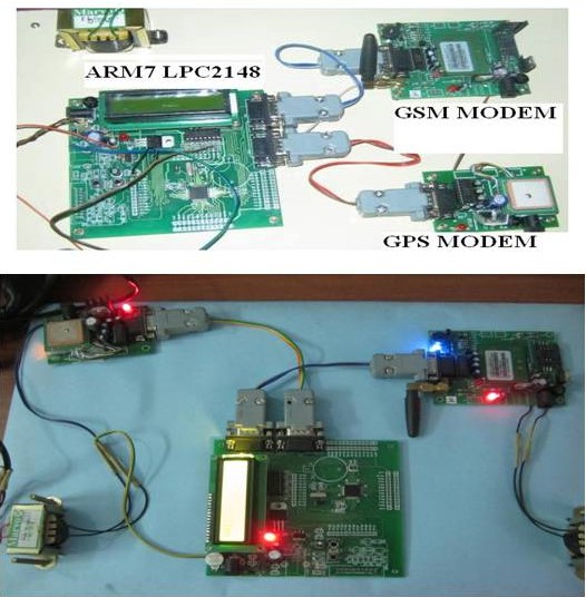
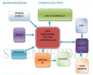
In the vehicle section, the equipment of this project is placed inside a vehicle is not visible to others. Here we have GPS (Global Positioning System) module by which we can get the graphical location of the vehicle and these location values are displayed on the LCD (Liquid Crystal Display). Initially the GPS continuously takes the data from the satellite and stores the latitude and longitudinal positions in microcontroller’s buffer. If we want to know the path of the vehicle we need to send a message to the GSM which gets activated by receiving our message. At the same instant the GPS gets deactivated with the help of controller. As soon as the GSM gets activated it takes the last received latitude and longitude positions from the buffer and sends a message to the particular number which is executed in the program. After the message has been sent to the user the GSM gets deactivated and similarly the GPS gets activated. This is a cyclic process.
The applications for this project are in military, Navigation, Automobiles, Aircrafts fleet management, remote vending, remote monitoring, remote control, security systems, teleservices, etc.
TECHNOLOGY:
GPS:
GPS (Global Positioning System) technology is used to find the location of any object or vehicle to monitor a child continuously using satellite signals. Three satellite signals are necessary to locate the receiver in 3D space and fourth satellite is used for time accuracy. GPS will give the information of parameters like longitude, latitude and attitude. With the help of these parameters one can easily locate the position of any object. In this GPS technology, the communication takes place between GPS transceiver and GPS satellite.
GSM:
GSM (Global System for Mobile communications) is the technology that underpins most of the world’s mobile phone networks. The GSM platform is a hugely successful wireless technology and an unprecedented story of global achievement and cooperation. GSM has become the world’s fastest growing communications technology of all time and the leading global mobile standard, spanning 218 countries. GSM is an open, digital cellular technology used for transmitting mobile voice and data services. GSM operates in the 900MHz and 1.8GHz bands GSM supports data transfer speeds of up to 9.6 kbps, allowing the transmission of basic data services such as SMS.
SOFTWARE AND HARDWARE TOOLS:
SOFTWARE TOOLS:
- KEILUV4 IDE TOOL
- ISP PROGRAMER
- EMBEDDED C PROGRAMMING
- FLASHMAGIC
HARDWARE TOOLS:
- ARM7TDMI LPC2148
- MAX232
- LCD DISPLAY
- POWER SUPPLY
- ENGINE
- DRIVER IC
- GPS MODULE
- GSM MODULE
- RS232
RESULT:
Taking ARM as platform, and GPS and GSM as wireless data communication platform, Vehicle Positioning System is small, stable and reliable, with small delay, which can effectively overcome the past disadvantages of poor real-time and high operating costs existed in the system. Vehicle positioning system is trying to achieve complexion of positioning technology, integration of positioning systems, and network of location-based services in the form of the current Client / Server. It is believed that the system will have broad application prospects.




Post Comment
You must be logged in to post a comment.